
Coal Creek & Morrissey, Fernie BC
DISCLAIMER: Snowmobiling in the mountains carries inherent risk. It is up to the rider to gain the necessary training, skills and experience required for safe snowmobiling in the mountains, and to exercise caution in areas with avalanche danger and other hazards.
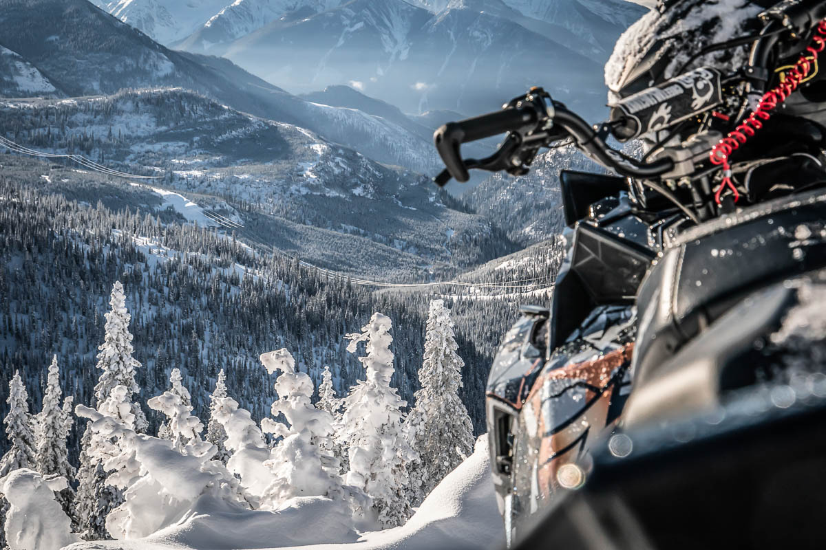
Nestled within the crook of a dogleg valley in British Columbia’s Southern Rockies, stands the historic mining town of Fernie, BC, where the air is thin, the stoke runs thick and sledding burns like coal in the soul.
This resource-extraction turned four-season-resort town is known for its rich history, eclectic local charm and a legendary nine meters of annual snowfall. Long established as a powder skiing, mountain biking and fly-fishing mecca, Fernie is one of the fastest emerging snowmobile destinations in BC today.
Meeting that demand is the Fernie Snowmobile Association (FSA), which has worked diligently to establish land use agreements and infrastructure, and now provides over 160 km of maintained trails throughout five riding areas.
At the heart of it all are the flagship Coal Creek and Morrissey trail networks.

Terrain
- Logging road arteries connecting expansive cut blocks, hidden meadows, technical lines, rolling hills and ridges
- Endless treeline and below treeline riding suitable for a variety of ability levels, including families
- Two warm-up cabins
Season
Open 7 days a week from mid-December to April
Grooming
Sunday, Wednesday, Friday and Saturday
Trail Fee
$25 day use fee or $185 annual primary membership
Coal Creek
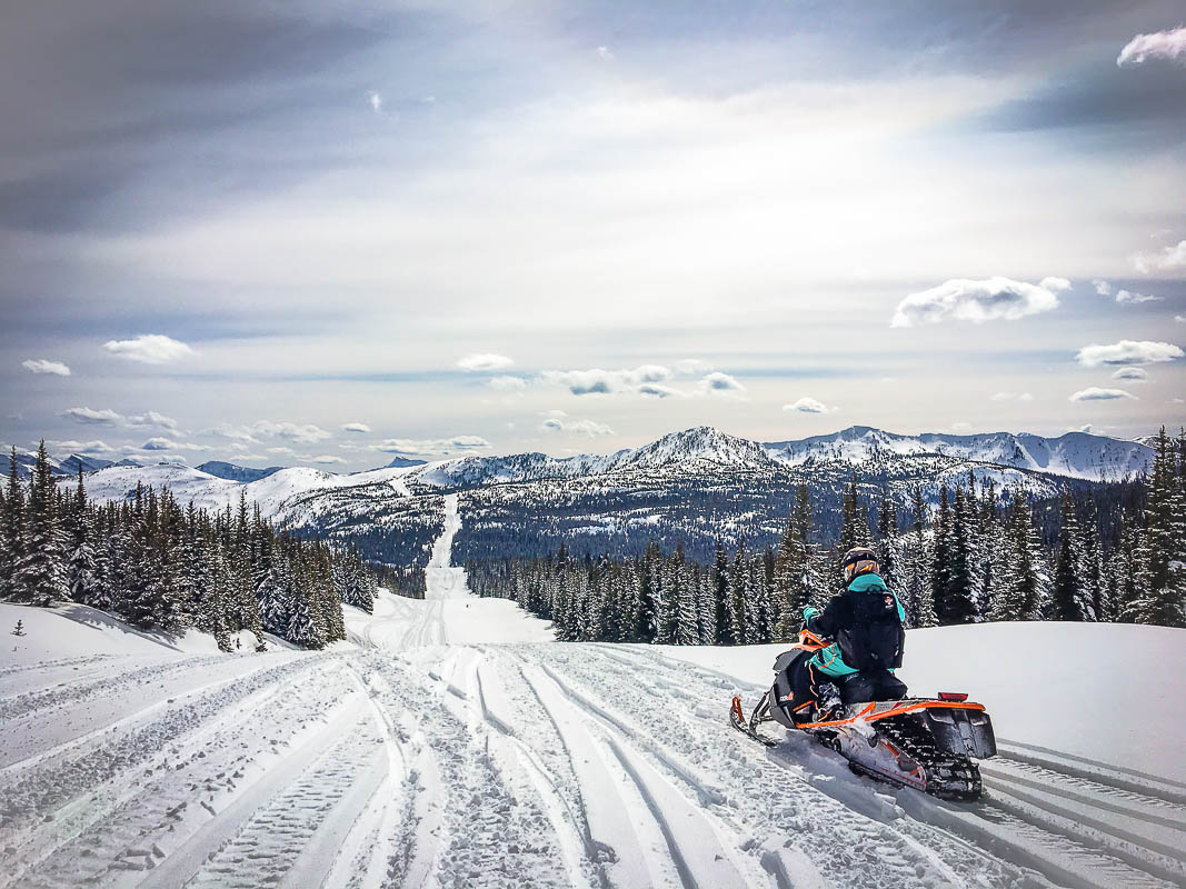
Located just five minutes from downtown, Coal Creek is a wide and impeccably groomed trail gently ascending its namesake drainage. After crossing a large avalanche path just beyond the staging area, the first branch on the right is called The Matheson. This small drainage offers novice and intermediate glade riding on low visibility days.
Continuing farther up Coal Creek, riders will reach a major dogleg junction. Hang a left here, up Paige’s Draw, to reach Martin, Luke and Leech. These areas require a two meter deep snowpack for enjoyable riding, but are incredible boondocking zones if you are keen to explore the hundreds of acres of new logging.

Proceeding straight at the Paige’s Draw intersection, riders will reach a key Y-junction. To the right, the Summit Trail contours through The Burn before joining up with the lower Morrissey Trail. Alternatively, riders may continue on ahead to get to the Rolling Hills Cabin.

Rolling Hills Cabin
Directly across from the Rolling Hills Cabin is the broad, south face of Leech Ridge. The ridge can either be absolutely loaded with snow or positively scoured, depending on how the storm cycles roll through. If everywhere else is wind hammered, give Leech Ridge a shot.
Directly behind the cabin is one of Fernie’s best family zones: The Burn. It is a playground full of small bowls, drops, and fun little climbs that beckon all ability levels, and it has easy access for family spectators.

The south end of this plateau is the Rolling Hills proper. This area provides more advanced riding options and some great sheltered lines that hold snow for days after the last storm.

Continue farther south past the cabin, through the forest and along the flowy Doug Dean Trail to connect with the upper part of the Morrissey Trail.
For families, groups of mixed ability levels, or sledders new to the area, joining this groomed network of trails makes for an enjoyable full-day loop with warming cabins close at hand.
Morrissey
The Morrissey staging area is located 20 minutes south of town. It offers more parking options than Coal Creek: a flat, lower lot for large trailers and an upper lot for trucks with sled decks.
The groomed trail meanders up the canyon through privately owned cat-ski terrain, so it’s important to stay on the designated trail until you reach the power line.
Past the power line, the trail intersects with the south end of Summit Trail to the left, which leads to the Rolling Hills Cabin.
The next major junction is a four-way confluence of the Doug Dean Trail (left), The McEvoy East (straight) and a short, bushwack (right) that will take you to Minnesota Flats, aka Wrangler’s Cabin Meadow. In order to reach the new Wrangler’s Cabin itself, continue straight on the McEvoy Trail to reach the turn off.
The McEvoy Trail takes riders on a loop into the Flathead, returning to the meadow via a section of the Pipeline Trail. This scenic, groomed circuit features some benched play zones (great for novice riders and families) and ample treelines for more experienced riders to dip into along the way.
The Notch (aka Sportman’s Ridge) can be reached by heading south down the Pipeline Trail from the east end of Wrangler’s Cabin Meadow. A series of climbs and descents over the Double Hills can be challenging, as can the open water or tenuous snow bridges in the early and late season. The FSA installs bypass trails once there is sufficient snow coverage.
The grooming ends at The Notch, the summit of a knife edge ridge casting impressive views south to the USA border. Note that the prevailing winds can play havoc up here, creating large cornices, fetch areas of scoured bedrock, rimed trees and ‘fat’ fans below the headwall. On the days following a storm, the endless rolling glades and meadows below can be heaven. Anything more than a week after the last snowfall though, and you are likely to be riding styrofoam until the next reload. Good thing then that big winter storms roll through Fernie on a regular basis.
– Nicole