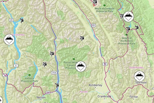
Here’s what Avalanche Canada’s New Forecasting System Will Look Like
For many years now in Canada, we’ve become accustomed to seeing the avalanche hazard forecast organized by Avalanche Canada into well-established regions, some of which cover massive areas. These large regions in many cases are so vast that the snowpack, weather and avalanche hazard can vary quite significantly across even a single, expansive region.
This has been a long-standing problem for Avalanche Canada, the organization that is tasked with reporting hazard forecasts for huge swaths of avalanche terrain across our nation, and especially in British Columbia where the vast majority of avalanche terrain exists.
At one time, it was commonly said that Avalanche Canada’s South Columbia region covered as much ground as the entire country of Switzerland. That region has since been split into smaller forecast regions, but still, just one of those chunks, the Purcell Region, stretches nearly 300 kilometers in length from Golden in the north to the U.S. border in the south.
The problem is that with such large regions, it is not uncommon to have significantly different snowpack stability or hazard conditions in some parts of a region than in others at the same time, even across a single range.
Avalanche Canada is seeking to address this issue with its new forecasting system, which will be presented on the Avalanche Canada website and on their mobile app this winter.
New Avalanche Canada Forecasting System
The biggest change to the new forecasting system that users will recognize immediately is that avalanche hazard forecasts will no longer be published by familiar regions with established and static boundaries (such as the ‘Sea to Sky or ‘North Rockies’ for example). Even the names of the regions will be gone.
Instead, the forecast regional boundaries will be dynamic—that is to say that they can and will move in response to the changing conditions and hazard present at the time.
For example, if one part of the former Sea to Sky region is behaving more like the avalanche conditions on Vancouver Island, that area could then be lumped into the region including Vancouver Island, creating separation and a distinction between the forecasted hazard ratings of those areas that are close in physical proximity yet presenting different avalanche hazard conditions.
These boundaries will be assessed and determined by Avalanche Canada forecasters daily, and will shift as needed to reflect smaller, more local hazard conditions.
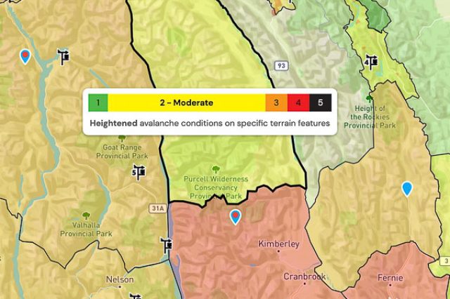
To further illustrate this change, let’s go back to our example of the former Purcell region. If the avalanche hazard in the north of the region is different from what’s in the south (as is often the case in this region in particular) that will be reflected by a regional boundary between those areas that separates the area into regions with different forecasts—which may or may not be then associated with other adjacent areas with similar conditions. It all depends on what the conditions are like at the time and where.


The regions as we know them are out the window. Moving forward, the size and shape of the avalanche regions will be determined by the conditions rather than a line drawn on a map.
Another really big benefit to this new way of presenting the forecast regions is that a small area affected in the short term by a weather system can now have its own forecast.
Other Changes
Avalanche Canada has also made the forecast map easier to read and understand how the hazard is different in specific areas by colour coding each dynamic region with its highest danger rating based on the North American Public Avalanche Danger Scale. If the highest danger rating for an area is ‘Low’, then the area will be coloured green. If it is ‘Moderate’, it will be yellow, and so forth according to the standard danger hazard colour scheme. Black is bad.
In some cases throughout winter, users will recognize that adjacent regions share the same colour—this indicating that the highest danger rating is the same in those areas. However, the new Avalanche Canada forecasting system allows those regions to have separate forecasts, which may reflect different problems or snowpack conditions that backcountry users need to be aware of. An example of this might be an area with a wind slab problem causing a danger rating of ‘Moderate’, which may be adjacent to an area with a persistent weak layer resulting in the same danger rating. Different problems require different approaches, even when the resulting hazard rating may be similar.

An example of a case in which adjacent areas are separated not by danger rating, but by a difference in avalanche problem or condition that calls for separate forecasts for those areas.
Another way that the organization has simplified the interface is with the implementation of a search bar for riding areas. If a user is not sure which forecast affects the area they plan to travel through, or can’t locate it on the map, they can search for the name of the area and choose from options presented. The search result will show the user the area they plan to ride on the map and present the forecast information for whatever particular region that area falls under based on the specific local conditions of the time.
Users may also continue to find the appropriate hazard forecast by using the map to identify which regional forecast pertains to their specific destination for the day. On the Avalanche Canada website, users can hover their mouse over a particular region for a short description of the danger rating.
What Won’t Change
The methods used to gather information and produce the forecasts will remain unchanged.
There will also be no changes to the areas covered by the forecasts.
The structure and the layout of the avalanche hazard forecasts will remain the same, and they will continue to present the same detailed information as usual.
And finally, the Mountain Information Network will still be featured prominently.
New Avalanche Canada Forecasting System
The result of this forecasting system change is that Avalanche Canada will be able to provide more accurate forecasts that reflect more localized conditions, without the limitations of providing blanket information for large areas with static boundaries.
Between October 14-28, Avalanche Canada is providing users a sneak peek of the new forecasting system interface, before it goes live in time for this winter. To check it out, you can browse to https://sneakpeek.avalanche.ca/en/map
Avalanche Canada will be fine-tuning the system throughout winter, so users may expect to see small changes as the new forecast system is implemented and dialed into to improve the safety of backcountry users in Canada this winter.


