Glacier National Park’s Avalanche Control Program Wages a Modern-day Battle in Rogers Pass
The savage terrain of Rogers Pass seldom sees peace in winter.
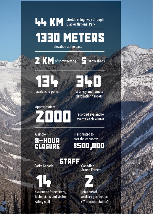
Sledders know Rogers Pass to be the crux of the Trans-Canada Highway as it connects the rest of Canada to some of the best riding areas in British Columbia. At 1330 m, the pass dissects the Selkirk Mountains through the heart of Glacier National Park, and is flanked east and west by the towns of Golden and Revelstoke respectively.
It is less well-known, however, that Rogers Pass is home to one of the most advanced avalanche management systems in the world. With 134 avalanche paths threatening the safe passage of the flood of vehicles that travel through each winter day, Glacier National Park staff and the Canadian Armed Forces have developed a world-class forecasting and avalanche control program.

The Trans-Canada Highway is exposed to 134 avalanche paths as it winds its way through the narrow valley that is home to Rogers Pass. Photo: J. Daniluck
While the program is most famous for firing Howitzer artillery rounds at the mountainside, there’s an entire dance of sophisticated steps that takes place before the explosives come out.
The goal is to limit the occurrence of monster slides like the ones that haunted the early days of travel through the corridor, causing the tragic loss of many lives.
A Relentless War at Home
Diplomacy First
Keeping the highway safe starts with static defences—preventative measures that keep snow off the highway near some of the most defined avalanche paths. The most obvious of these are the five snow sheds within the park and three more just outside (and the berms around them that help divert snow), which have been in place for decades.

But in the last few years, Parks Canada completed a burly new static defence. There are now two kilometers of snow nets on Cougar Corner, the largest such installation in the western hemisphere and one of the most complex in the world. Keeping snow in the start zone prevents the occurrence of avalanches in the first place. These nets corral snow in place, high up in three steep avalanche paths that have a tendency to slide earlier or at different times than other areas.

Know Your Enemy
But avalanche control, at its heart, is not static; it’s the definition of dynamic. Which is why Parks Canada’s top-notch forecasting team must accurately analyze a range of moving pieces daily to help keep Highway 1 open as much as possible throughout the winter.
The first step in solving the puzzle is gathering weather data. Parks Canada uses a series of radio telemetry weather stations to monitor wind, temperature, humidity, precipitation and accumulation. The information is transmitted to headquarters, where it is collated with results collected from the field.
The second step is to collect data on what’s happening in the snowpack. Avalanche technicians head out into the mountains each day to dig snow profiles for in-depth looks at the layers in the snow. This information provides clues as to where avalanches could start, how big they might be and if they could propagate across slopes.

Parks Canada Avalanche Technicians gather snowpack data in the field. Photo: J. Daniluck
Current avalanche activity is the third source of data—some of which is collected the old-fashioned way, by simply driving along the highway to observe the hundred-plus paths.
But this method is also being modernized. There is a three-year project underway in which a system of 13 overlapping arrays that use infrasound and radar will be used to detect avalanches in real time. Each array has four to five sensors, spread out 50 meters away from a centralized point. These can detect waves travelling at the speed of sound, at a frequency below what the human ear can hear. The advanced technology relays the direction and magnitude of an avalanche with only a minute delay.

Secure the Perimeter
Armed with this supply of information, the forecasting team will constantly analyze the avalanche situation, and when necessary, make the call to close the highway for control work. The team announces closures with as much advance notice as possible (often the night before) so that drivers can plan their travel accordingly. Highway closures are posted on the Ministry of Transportation and Infrastructure road conditions website, DriveBC.

“When we do these closures, it’s for the safety of the people travelling,” says Parks Canada Senior Avalanche Officer, Jeff Goodrich.
Jeff Goodrich, Parks Canada Senior Avalanche Officer“Be prepared, check DriveBC and don’t travel during the times we’re doing control. At any time you’re driving through mountain passes in winter, it’s good to be prepared with a full tank of gas, extra food, water, warm clothing and a sleeping bag.”
“Our philosophy is to try to cause more frequent and smaller avalanches. If they stop just short of the road, that’s ideal because it’s a reduced threat to the highway and we don’t have the big cleanup times. When avalanches get large and we’re not able to keep them off the road, that causes longer closures,” says Goodrich.
Commence Fire
Finally, at this point, the guns come out.
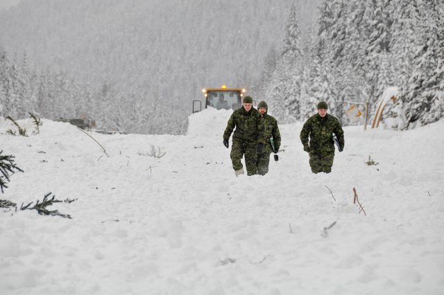
While vehicles are stopped in “ponding areas” (safe zones on either side of the pass), teams of Canadian Armed Forces set up 105 mm Howitzer artillery guns at two of 17 permanent gun placements along the highway. At the first placement, the gunman sights in on the target. The lead forecaster gives the order to fire, and snow, hopefully, plunges down the mountain.

Canadian Armed Forces readying a 105 mm Howitzer artillery gun for avalanche control in Rogers Pass. Photo: Rob Buchanan
“It’s amazing to watch the power of a running avalanche,” says Goodrich.
“When you see that, you know you don’t want to be anywhere close to one of those things when it’s running full-path.”
While the first team wraps up operations and prepares to move the Howitzer to the next placement, the forecaster is already en route to the second gun team, eliminating delays for setup and cleanup times between shoots. The guns leap-frog each other along the highway with an efficiency that comes from 58 years of partnership with avalanche teams at the pass.
Known as the “Snow War”, in a nod to the ongoing violence of these volatile mountains, the avalanche control program at Rogers Pass is the Canadian Armed Forces’ longest-running active military operation.

At the same time the Howitzers are bombing start zones in the heart of the corridor, forecasters fire remote control explosives on the east and west peripheries with the touch of a laptop key—yet another system that combines old, yet still effective, methods with new technology.
Withdrawal
After cleaning up any debris that may have blanketed the road, the Trans-Canada is re-opened to the thousands of drivers who safely traverse this stretch of highway every day—most of them blissfully unaware of the high-stakes, perfectly-executed operations safeguarding their journey through one of the wildest avalanche battle zones on earth.
– Cassidy