Foggy Day Ride Guide – Trout Lake, BC
June 11, 2021: The British Columbia Ministry of Forests, Lands, Natural Resource Operations and Rural Development has slated the Rady Creek Forest Service Road (that is used to access Foggy Day) for deactivation. This decision was made without public and stakeholder consultation. Please consider signing the petition to keep the Rady Creek FSR open for recreational access to this incredible area.
More information about this issue and what’s being done can also be found on the British Columbia Snowmobile Federation site.
August 16, 2021: A letter from Regional Executive Director, Garth Wiggill, of Kootenay Boundary Region suggests that due to the 2021 wildfire situation requiring the re-deployment of key engineering staff, the planned deactivation of the Rady Creek FSR would be postponed for a year, which would allow more time for further consultation.
Please note that all Trout Lake snowmobile areas, including Foggy Day, are part of the Central Selkirk Snowmobile Management Area (CSSMA) which is undergoing a Trial Adaptive Management Strategy. The terms of the permit for access to ride this area will be that you must be a member in good standing of either the Arrow Lakes Ridge Riders or the Trout Lake Recreational Club and you must check the maps daily to obtain the zones that are open to snowmobiling/snowbiking for that day. The closed zones will be monitored by the Conservation Service and local riders will be providing education or outreach. Anyone who is found to be in a closed zone or not meeting the terms of the permit including membership will face fines.
More information can be found at: https://snowmobileselkirks.ca/
DISCLAIMER: Snowmobiling in the mountains carries inherent risk. It is up to the rider to gain the necessary training, skills and experience required for safe snowmobiling in the mountains, and to exercise caution in areas with avalanche danger and other hazards.
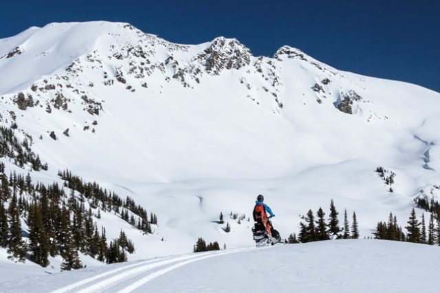
The area, which starts at Rady Creek FSR is a large alpine snowmobile zone that benefits from low traffic, easy navigation, and more playful features than you have gas enough in your tank to enjoy. Being on the receiving end of Trout Lake’s renowned snowfall (and the weather that goes with it) may have been how it got its name, but you’ll appreciate it to the max if you can nail it on a sunny day. Get ready to log some air-time.

Foggy Day, Trout Lake BC
Riding
- Amazing alpine freeriding
- Lips, cornices & drifts galore
Drive
- 15 km gravel from Trout Lake
Trail
- 10 km ungroomed road & skid trail
Other Features
- 5 large and numerous smaller bowls
- Fairly easy to navigate when the visibility is good
- Access trail is bumpy with steep sides
- Adjacent to Silvercup caribou closure

Ride Guide: Foggy Day Snowmobiling Trout Lake
To The Trailhead
From the gas station in Trout Lake, BC, drive south on Hwy 31. The pavement ends quickly and the road becomes rather narrow and winding, leaving you to wonder how this can be called a highway at all.
Regardless, continue along taking care as the road gains elevation and then cuts through a number of sharp ravines. At around 15 km from the gas station, the road crosses a deep ravine, and just a few hundred meters on the other side is the Rady Creek FSR where the sledding starts. Look for the “Spur 145” sign.

There is no parking there, unless you can manage to squeeze your truck along the side of the road, making sure there is room for traffic including logging equipment to pass. The best bet is to continue along just under another 1.5 km to a small gravel pit where you can turn your rig around and park.
From there, you’ll need to ditch bang your way back to the Rady Creek FSR.

To The Zone
Take note of the caribou closure sign as you head up the trail, which shows the location of the Silvercup Ridge closure. The closure includes an easily-accessible bowl at the back of the Foggy Day zone, so it is important to know where it is, and to respectfully refrain from riding there.

Navigating the trail up is fairly straightforward, just stick to the main path and keep going up. At 5.5 km the ungroomed road cuts across the top of a large cutblock with a fantastic view of Trout Lake from 1600 m elevation. From there, the trail cuts back into the forest and follows a retired mining trail. The trail is quite steep and narrow, as it heads up a remarkably steep hillside covered with dense lumber. This singletrack trail doesn’t require any special skills to navigate, but riders should pay attention—an off-trail slip up here would, without a doubt, be costly, and it could prove difficult to recover your sled at all. Keep that in mind on the way down when you’re tired after a long day and more likely to get thrown off-course by the whoops.
Nearer the top, the trail cuts through a ridgeline ravine. At 9.2 km there is a branch to the left that can be used to access a bowl to the north of the main area. Stay right on the main trail to continue to Foggy Day proper.

Another 400m will take you to a ridge that ascends up to the main zone. This ridge catches a lot of wind, evidenced by the numerous wind lips and drifts here, which makes crossing this section a little tricky in flat light. Persevere, and several hundred meters later you’ll be situated over the main riding area to the south.

The Riding
Counting the north bowl, which is accessed separately from the rest, Foggy Day is a large zone made up of 5 big bowls, and several attached mini-bowls. Put together, it all adds up to one giant alpine playground.

The first bowl to the south offers some open slopes on its east flank—which can be climbed to gain the next bowl in that direction—and some benchy tree riding to a lake down below. The easiest way to push farther back is to ride the bench above the lake to a saddle in the ridge to the southeast.
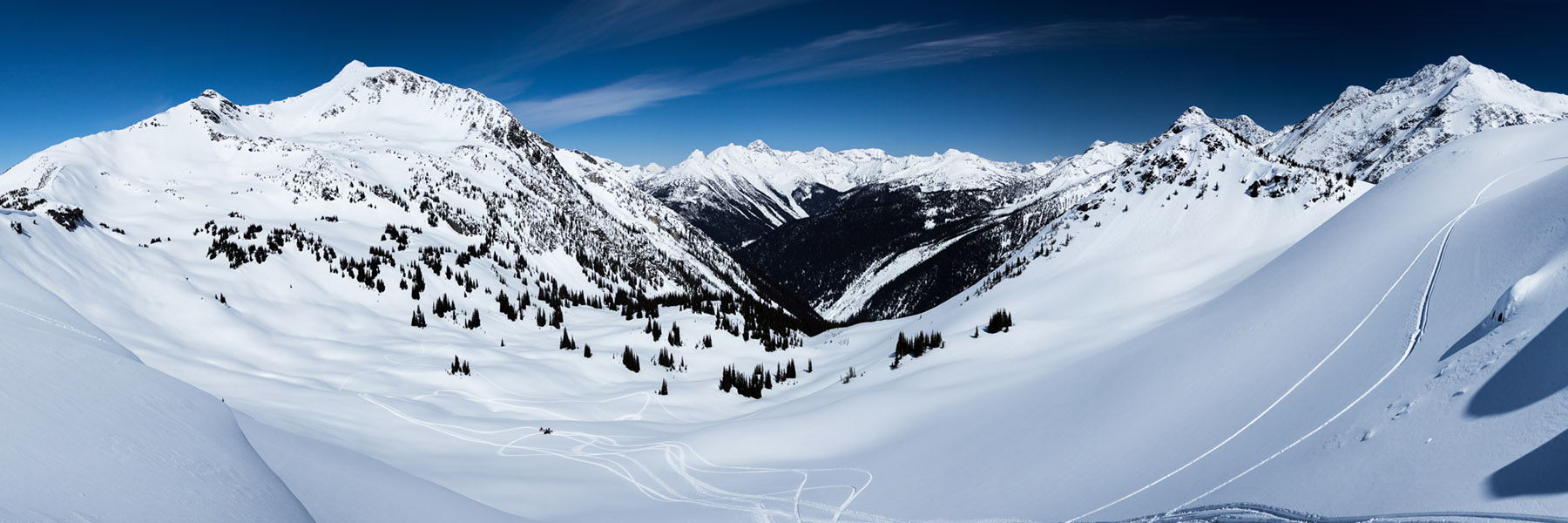
The remaining three bowls on the way to the back are mostly open alpine, with a smattering of trees and small lakes here and there. It’s all pretty friendly for travel, with many benches and low slopes, and there should be no difficulties in getting around. Another plus is that you can explore this area with little exposure to avalanche hazard. But it’s there in the form of hills to climb if you want it. There are no chutes per se, just plenty of big open slopes if you feel the conditions are safe enough to test them out.

The best part of Foggy Day is the nature of the terrain, which creates endless freeriding opportunities. There are bumps, lumps, drifts and cornices galore, which make for jumps ranging in size from the kind where you think you caught air—only to look back and see that your track never actually quite left the snow—to something you might see in the latest 509 web series.
The biggest of all the bowls is the farthest back at the headwaters of Ottawa Creek, and to the west of Fays Peak—the highest point of land on Silvercup Ridge at just over 2800m. At the south end of it you can sled right up to a notch in the shoulder of Fays Peak, which is marked with heli-stakes and what looks like a blown over marker, no doubt intended to sign what is the northern edge of the caribou closure. Closure aside, there is no point traveling beyond this notch, as the winds in this part of the ridge play havoc on the snowpack, making for unworthy sledding in windblown and shallow snow.

Please join a snowmobile club and support the BCSF in the effort keep riding areas like Foggy Day open for snowmobiling.
To read about more amazing riding areas in British Columbia and what’s at stake, check out some of our Ride Guides here.
– MS