
Storm Cycle Creates High Avalanche Hazard Across BC and AB
Heavy snowfall and strong winds have combined to create very unstable snow conditions across nearly the entire province of BC and into Alberta. The Avalanche Canada bulletin hazard rating for Friday is high at most elevations for nearly all mountainous areas of the province.
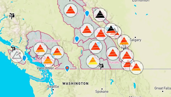
The Coast has been hit the hardest, with large snowfall amounts and high winds creating touchy storm slabs.
Farther inland, Avalanche Canada lists deeply buried suspect layers of facets, surface hoar and sun crust from mid-December as a concern, as surface layers are further loaded with storm snow.
Moving east into the National Parks, conditions are such that Parks Canada has been prompted to post ‘Extreme’ danger ratings in the alpine and treeline of Yoho and Banff National Parks, and at all elevations in Jasper. Parks Canada forecasters have stated, “It’s time to stay out of avalanche terrain – avalanches will run far into the run out zones.” It should be noted that ‘Extreme’ danger ratings are rarely used.

Saturday will offer unsettled conditions for much of the province, causing the avalanche hazard rating to downgrade to ‘Considerable’ in most regions of the province. However, with such recent, rapid loading, Avalanche Canada is reporting that conditions will remain primed for human-triggered avalanches.
Riders would be well-advised to take extra caution until the new snow has had a chance to adjust to the new loading. Be sure to visit Avalanche Canada for the avalanche forecast if you plan to ride this weekend. Stay safe and have fun out there.
– MS